Thursday, February 28, 2013

"Enduring Patagonia" review


When I was living at the Grand Teton Climber's Ranch in summer 1996, I attended an extraordinary slideshow by Greg Crouch, who had recently climbed Cerro Torre.  Greg had spent an entire season trying and trying and trying again to scale the peak amid some of the world's worst weather.  He and his partners waited out the regularly ferocious and prolonged storms in a squalid, mice-infested shelter miles from the nearest town.  All climbing was done in weather windows that would open for a day or two before slamming shut for a week or three. The final successful ascent required an impromptu bivouac a few meters below the tippy top.

That particular Cerro Torre climb was one of several major ascents Crouch made in the region during the 1990s.  In 2001, he published an outstanding book about those excursions, entitled Enduring Patagonia.

The author enjoying typical conditions on Cerro Torre.

Crouch's trips to the Chalten Massif all seem to have a few things in common.  They each involve:
(1) multiple months;
(2) one horrible storm after another;
(3) waiting out storms in remote, dumpy camps for the majority of the time;
(4) extremely technical rock and ice climbing;
(5) constant uncertainty about the circumstances and the outcome;
(6) dangerous retreats through storms at night; and
(7) clothing that is rarely if ever washed and possibly never changed.

Crouch's determination in the midst of these mostly miserable conditions is astonishing.

The author in the notorious (noTORREous?) camp.  This is apparently how the majority of time is spent on a climbing trip in Patagonia. 

But Crouch is more than a determined alpinist.  He is also an excellent writer. Enduring Patagonia is a totally engaging read.  My only complaint is that there were not 200 more pages.  The story is compelling, the prose is solid, and Crouch writes with an honesty and lack of pretension that is starkly genuine.

It also helps that Crouch comes across as a very likeable fellow. In fact, he is a likeable fellow.  I know that, because a day or two after the previously mentioned slideshow, I encountered Crouch again -- on the summit of the Grand Teton.  Descending the mountain together, I was regaled with some of the backstory from his Cerro Torre odyssey.  One detail I remember was how he funded the trip -- by installing ball-washing machines in ball pools.  And I was delighted to find a sustained discussion of that decidedly odd job, and others, in Enduring Patagonia. 

Many photos from Crouch's mountaineering adventures are posted on the Enduring Patagonia facebook page and his personal website.

The ebook and actual book are available in many places, including here.

Crouch recently published another book which took him a decade to write, entitled China's Wings.  Find out more about that here.

The author on the summit of Fitzroy.

 All images in this article are courtesy of Greg Crouch.   


Friday, February 1, 2013

Rock Song About Mammoth Lakes


The first song on my album Breach (2013) is "I Don't Want To Think About Her Anymore". The lyrics are based on an experience I had in Mammoth Lakes, California many moons ago when I was a climbing bum. The song can be streamed here or on Spotify:


Here are the lyrics:

I met her in the mountain town of Mammoth Lakes.
She had a smile that could make the earth quake.
Always surrounded by a half a dozen guys
with eyes fixed firmly on the prize.

Lucky me I became the chosen one,
for a few weeks at least in the sun.
In my mind she was wearing a tiara
and I was the king of the Sierra.

I don’t want to think about her anymore. (2x)

She could lead 5.9 follow 5.11.
Belaying her I was in heaven.
But then I slipped and took my fall from grace,
introduced her to the mountain ace.

She and I were heading out to the hot springs.
Saw him on the street and said, “Hey, get your things.”
One look at her he was immediately smitten.
Alarm bells rang when she purred like a kitten.

I don’t want to think about her anymore. (2x)

Meanwhile, back at the hot springs,
skinny-dipping we could see everything.
That really didn’t work out well in my favor,
because they were both players.

Game over for the tall, skinny, white guy.
I should have known when I saw the look in his eye.
They never thanked their match-making fairy,
even though they got married.

I don’t want to think about her anymore. (3x)

Game over


©℗ 2013 Sam Page

Thursday, October 11, 2012

Seven Pines Trail, Mt. San Jacinto

On October 6, I made my maiden voyage up the Seven Pines Trail.  Though I've taken at least four other routes to San Jacinto Peak, I'd never gone this way.  Unusually, I found the bottom of the hike (the Seven Pines Trail stretch before the Deer Springs Trail intersection) to be the most scenic.

It took Patrick Moran and I about 9.5 hours at a conversational pace to complete the roughly 14-mile round trip.  With the two notable dips on the Seven Pines Trail (to cross the North Fork of the San Jacinto River), it's about 5000 vertical feet.  I left south Orange County at 4:30AM and was back unloading the car at 7:00PM. 

It's worth mentioning that the Seven Pines Trail is hard to follow in places. We found ourselves temporarily off-trail on several occasions and had to make an effort to re-find the trail at the first saddle.  It's also worth mentioning that the river was running, which surprised me considering how dry it has been.

San Gorgonio

View from the summit of San Jacinto Peak. Snow Creek is down to the left, Kristen Peak is in center, and Leatherneck Ridge is on the right. 

Patrick on top

This photo was taken moments before the landslide ... just kidding.

 Heading down

Beautiful scenery on the Seven Pines Trail

A lovely hike

Thursday, September 27, 2012

"Buried in the Sky" review


Though I'm currently engrossed in producing my first full pop/rock album, I recently took some time to read Buried in the Sky: The Extraordinary Story of the Sherpa Climbers on K2’s Deadliest Day.  The book, published in 2012 and written by Peter Zuckerman and Amanda Padoan, revolves around the series of fatalities that occurred just below the summit of K2 in August 2008.  
I’ve read scores of books over the years that recount mountaineering epics, but this one is different.  Although it does what most readers of the genre will want it to do – it describes the accidents and their surrounding circumstances in the best detail the second-hand authors could muster – it also shines the spotlight on the people who have mostly labored in the shadowy fringes of the genre: the Sherpas. 

The first few chapters of the book trace the trajectories of the Sherpas involved in the disaster.  What these chapters do is firmly establish in the readers mind that the Sherpas are not second-class sidekicks, but fully-fledged actors on par with their (mostly) white counterparts.  And what the book as a whole does is show that, although many of the people involved are competent mountaineers, they are vulnerable human beings who willingly put themselves in harm’s way and suffered the consequences.    

If you are looking for a mountaineering book that portrays glorious heroes, this is probably not for you.  However, if what you are looking for is a very well-written, thoroughly researched and engaging account of a contemporary mountaineering disaster, then I recommend this book. 

Monday, August 20, 2012

The Pemi-Loop


The “Pemi-Loop” is a hiking circuit in the Pemigewasset Wilderness of New Hampshire’s White Mountains that climbs over 9000 vertical feet in 31.5 miles.  Backpacker Magazine called it the second hardest dayhike in America, making apt references to “knee-hammering rocks” and “long stretches of abusively rocky trail.” A few years ago I tried to do it in a day, but failed.  On August 7-8 of this year (2012), I did it in a more civilized manner by spending a night at the conveniently located Galehead Hut.  

Waking at 3AM in southern Massachusetts, I drove 3.5 hours to the Lincoln Woods Visitor Center and started hiking by 7:30AM.  It was a little steamy in the morning, so the 3000-foot ascent of Mt. Flume via the Osseo Trail was somewhat taxing.  From that craggy perch, I followed the spectacular Franconia Ridge Trail for five miles to the summit of Mt. Lafayette (5260 feet), which is the highest point in the wilderness. The stretch from Little Haystack to Lafayette, which is entirely above tree-line, was hot and crowded.  

 Crossing the Pemigewasset River at the start of the loop.

 The Osseo Trail

 Mt. Liberty from just below the summit of Mt. Flume. 

 View north from the summit of Mt. Flume. I need to climb over Lincoln and Lafayette on the left and then Garfield in the middle.  Many miles before I sleep ...

 Franconia Notch

 Mt. Lincoln from Little Haystack

 Looking back down the Franconia Ridge Trail toward Little Haystack, Liberty, and Flume.

 Mt. Washington from the summit of Mt. Lafayette.


Leaving the summit of Lafayette at 2:15PM, I needed to make good time to reach the hut for dinner, which is served promptly at 6PM.  That 6.6 mile stretch from Lafayette to Galehead Hut was brutal.  It took four hours, and I was really pushing it.  I did take a quick 
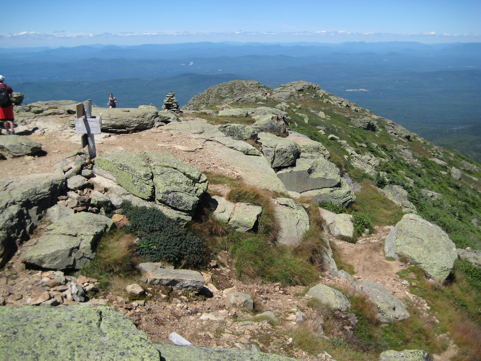
break on the summit of Mt. Garfield, however, to enjoy the fantastic view of the Pemigewasset Wilderness. 

Looking north from the summit of Mt. Lafayette.

Descending the Garfield Ridge Trail.

A nice spot in the forest, somewhere between Lafayette and Garfield. 

 The Pemigewasset Wilderness from the summit of Mt. Garfield. 


I reached the hut a little after 6PM, having hiked around 17 miles and climbed nearly 7000 vertical feet.  No wonder I was beat!  Being the last one to check in to bunk room #4, I was relegated to the least desirable bunk – the one on the fourth level (about 12 feet up).

Dinner was good, as was the company which I was suddenly thrown in with.  Sitting down to eat in close quarters with a bunch of strangers immediately after a grueling 11-hour hike was an interesting and not entirely pleasant experience, but at least I made it to dinner.  After dinner, one of the hut employees gave a talk primarily about logging in the Pemigewasset Wilderness, and then a few of us lingered outside and watched what I think was the international space station pass overhead.

Galehead Hut

 Sunset from Galehead Hut


Bedtime was unfortunately miserable.  After climbing the ladder up to the fourth bunk in the dark, I realized there was no ventilation up there.  Plus, the side of the bed was only an inch higher than the mattress, which meant that I could conceivably roll over and plummet twelve feet to the hardwood floor below.  Add to that a persistent, whining mosquito, some loud snoring from bunkmates, and a need to visit the rather grubby bathroom at midnight and you’ve got a recipe for a bad night’s rest.  Miraculously, I finally got some fitful sleep after about three desperate hours of staring wide-eyed in the dark.

At 6:30AM, a very nice violin solo by one of the hut employees rousted everyone from their bunks for a breakfast of oatmeal, pancakes, and bacon.  The bacon resulted in much oohing and aahing from hungry, calorie-depleted hikers.  By 8AM I was climbing the steep trail (1000 vertical feet in .8 miles) to South Twin Mtn. and becoming increasingly aware with each step of the oatmeal, pancakes, and bacon filling my belly.

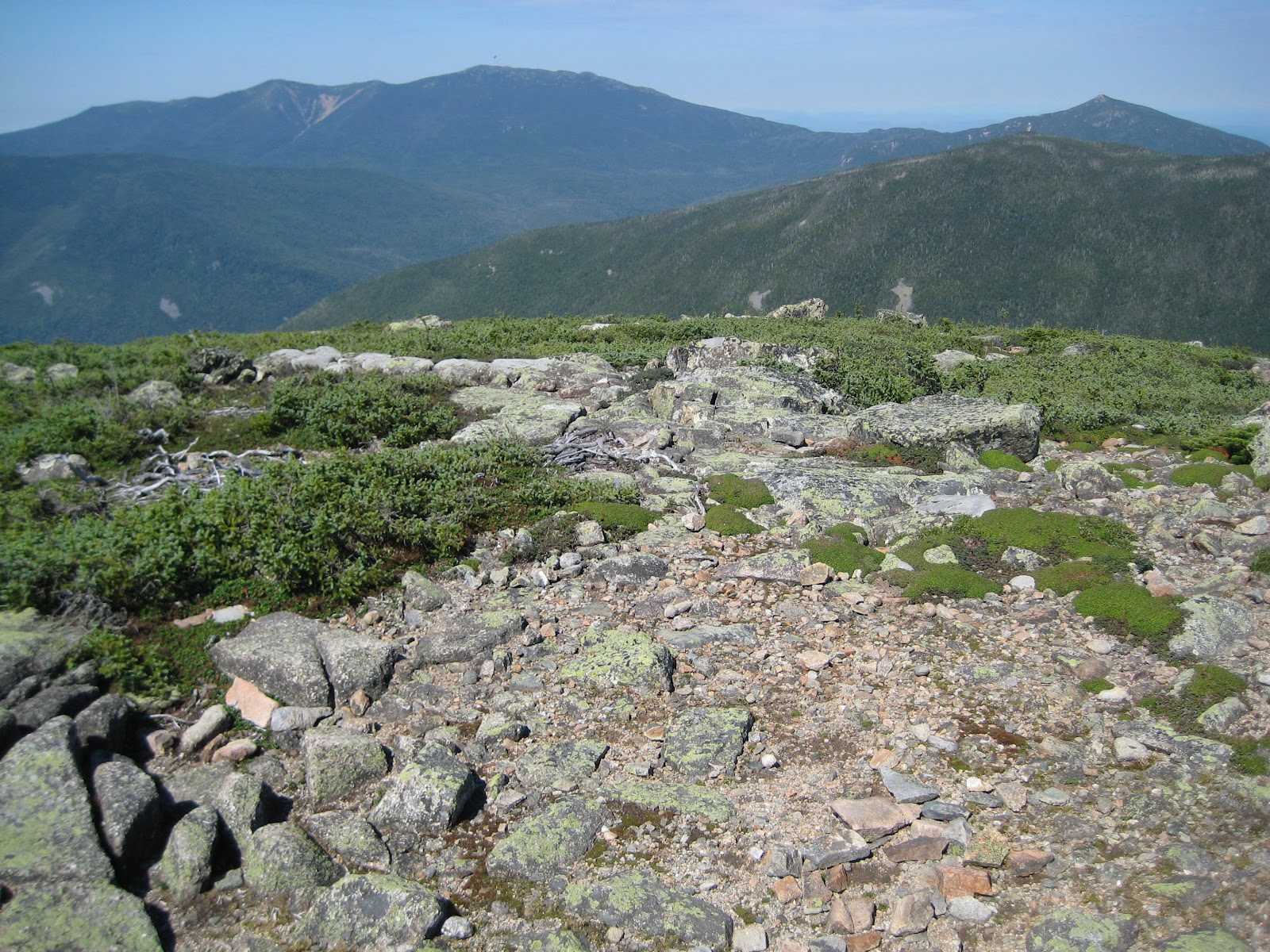
From South Twin, I headed south over Mt. Bond to Bondcliff, which might be my favorite summit in the White Mountains.  Nine miles from the nearest trailhead, Bondcliff is one of the remotest peaks in the Whites.  In fact, I had the summit to myself for the duration of my leisurely 30-minute break there.  Then, with a heavy heart, I said goodbye for the time being to these mountains I love so much – and to the memories they conjure up – and began the long plod down to the car.  

Crossing the footbridge over Franconia Brook, I allowed myself to wander down to water’s edge for an invigorating foot soak.  By 8:15PM, I was back in southern Massachusetts.  

A hazy view from the summit of South Twin.

 A typical stretch of trail in the White Mountains of NH.

The rocky trail leading toward the Bonds.

That's Mt. Lafayette in the center, viewed from near the summit of Mt. Guyot.

Bondcliff


 Recent slide activity on Mt. Bond.

 The classic view of Bondcliff summit.

 My moment of Zen

Wednesday, May 2, 2012

Santiago Peak, Telephone Pole Ridge again

Here's a quick photo dump from our April 15 climb of Santiago Peak via the unmaintained Telephone Pole Ridge (or whatever it's called).  For more details about the route, go here.  One note is that we were able to find the elusive Upper Joplin Trail on the descent -- it's a more or less direct route from Santiago Peak to the Lower Joplin Trail.

 After hiking uphill for an hour or so, it's still a long way away.

Miguel and Brian enjoying a clear stretch on the ridge.

Brian on some of the class 1+ terrain that plagued Miguel -- ok, not really.

Miguel savoring yet another batch of bushwacking. 

 Ahhh, out of the brush and onto the road just below the top.  

 The San Gabriels were looking pretty good.  

A rare sight in the Santa Anas.

Brian, Miguel, and me on top, with the San Gabriels in the background. 

Though I usually see a wrecked vehicle on every Santa Ana hike, this one surprised me because it was on a narrow stretch of the Upper Joplin Trail.  

Conquest.

Thursday, April 12, 2012

Pinos Ridge

On April 8, Patrick Moran and I hiked Pinos Ridge Trail to Pinos Peak (~4500 feet).  The beginning of the trail crosses the privately owned Lazy W Ranch, which we passed through with permission.  The fifteen or so bumps along the ridge turn it into 5500+ feet of elevation gain over ~16 miles round trip.  It's a real grind, especially on a hot day.

We tried to beat the April heat with a pre-dawn start, but the heat caught up to us on the totally exposed trail.  With about three miles to go, Patrick came dangerously close to heat stroke or something similar.  I won't get into the details of that here, but it is worth noting how even strong, well-prepared hikers can get blindsided in the hills. 

 Should I take direction from this sign?  If so, then what does that mean?

 Full moon (or close to it). 

 Lots of ups and downs. 

 Santiago Peak in the background with Bell Ridge in the middle foreground. 

 Patrick observing hundreds of jumbo ants on the summit. 

 Preparing to slog back up a big bump on the descent. 

 Old Sugarloaf. 

 Looking back at Pinos Peak. 

We had to move this bundle of joy out of the way to pass safely.  He went berserk when Patrick prodded him with a trekking pole.